
Satellites capture socioeconomic disruptions during the 2022 full-scale war in Ukraine
22.9.2023 12:16:06 EEST | Ilmatieteen laitos | Press release
Satellite observations show significantly reduced air pollution levels over the major Ukrainian cities, power plants and industrial areas.
Since February 2022, the full-scale war in Ukraine has been strongly affecting society and economy in Ukraine. Satellite observations provide crucial information to objectively monitor and assess the impacts of the war.
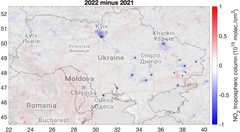
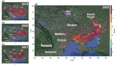
A new paper published today on Scientific Reports utilizes satellite observations of air pollutants and other relevant parameters from multiple platforms to assess the impacts of the ongoing war on the Ukrainian society. Satellite observations show that the concentrations of nitrogen dioxide (NO2), which is emitted through fossil fuel combustion processes, declined in 2022 over the major Ukrainian cities, power plants and industrial areas by 15–46%.
Such reductions reflect the decrease in population and corresponding emissions from the transport and commercial or residential sectors as well as the decline in industrial production, especially from the metallurgic and chemical industry, which led to a reduction in power demand and corresponding electricity production from power plants. Carbon dioxide (CO2) observations also indicate reductions in fossil fuel combustion, especially in eastern Ukraine, where the largest emission sources are located.
“During peaceful times, reductions in nitrogen dioxide concentrations as those observed here would be considered as a welcome improvement of air quality and human health. In this case, the observed changes tell a different story about the extent of the disruption caused by the war on the Ukrainian society and economy. Also, the reductions in fossil fuel consumption in Ukraine might have been partly offset by an increase elsewhere”, explains senior researcher at the Finnish Meteorological Institute Iolanda Ialongo, who led the work.
Exceptional fire patterns near the front line
Satellite imagery and fire detections indicate an anomalous distribution of fires along the front line, which are attributable to shelling or other war-related fires, rather than the typical homogeneously distributed fires related to crop harvesting. Satellite imagery data also show drastic changes over the city of Mariupol, which was attacked during the first three months of the war.
The signal from the hot smokes from the metallurgic industrial facilities in the city disappears from the satellite imagery after March 2022, which suggest an interruption of industrial activities, and, correspondingly, NO2 levels decreased.
The results are based on the NO2 retrievals from the European TROPOMI (TROPOspheric Monitoring Instrument), onboard the Sentinel 5 Precursor satellite, and the CO2 observations from the NASA’s OCO-2 satellite. Also satellite imagery from the Sentinel 2 satellite was analyzed as well as fire detections from the Visible Infrared Imaging Radiometer Suite (VIIRS).
The research was carried on at the Finnish Meteorological Institute together with colleagues from the University of Lviv (Ukraine) and USRA (USA). The Finnish part of the research was supported by the Ministry for Foreign Affairs of Finland via the Interinstitutional Development Cooperation Instrument (ICI), UHMC-FMI Meteorology project and the Research Council of Finland.
Keywords
Contacts
Senior researcher Iolanda Ialongo, Finnish Meteorological Institute, iolanda.ialongo@fmi.fi
Images
Links
Alternative languages
Subscribe to releases from Ilmatieteen laitos
Subscribe to all the latest releases from Ilmatieteen laitos by registering your e-mail address below. You can unsubscribe at any time.
Latest releases from Ilmatieteen laitos
Huhtikuu oli lämmin, kuiva ja aurinkoinen1.5.2026 12:07:02 EEST | Tiedote
Vaikka lämpötiloissa oli suurta vuorokausivaihtelua, huhtikuu oli selvästi tavanomaista lämpimämpi.
Eurooppa lämpenee nopeasti – helleaallot ulottuivat arktiselle alueelle asti vuonna 202529.4.2026 05:00:00 EEST | Tiedote
Eurooppa on maailman nopeimmin lämpenevä maanosa, ja ilmastonmuutoksen vaikutukset näkyvät laajasti eri puolilla mannerta. Vuonna 2025 lähes koko Eurooppa oli keskimääräistä lämpimämpi – vähintään 95 prosenttia maanosasta koki tavanomaista lämpimämmän vuoden.
Sää lämpenee vapuksi28.4.2026 13:18:22 EEST | Tiedote
Vappu tuo Suomeen selvästi lämpenevää säätä, kun lännestä saapuva säärintama nostaa lämpötiloja erityisesti maan länsi- ja eteläosissa. Vappupäivänä voidaan hätyytellä paikoin jopa 20 asteen lukemia.
Kevätmyrsky kurittaa viikonloppuna maan etelä- ja keskiosia24.4.2026 15:50:10 EEST | Tiedote
Pohjoistuuli voimistuu jo lauantaina iltapäivällä maan länsiosassa ja leviää sunnuntaina maan etelä- ja keskiosiin aiheuttaen vahinkoja. Runsaimmat lumisateet osuvat maan keski- ja itäosiin ja tekevät ajokelistä hetkittäin jopa erittäin huonon.
Matalapaine tuo puuskaisia tuulia ja lumisateita maan etelä- ja keskiosaan viikonloppuna23.4.2026 15:24:58 EEST | Tiedote
Ajokeli voi huonontua hetkellisesti lumisateiden takia, jotka ovat paikoin sakeita. Myös puuskainen tuuli voi aiheuttaa vahinkoja.
In our pressroom you can read all our latest releases, find our press contacts, images, documents and other relevant information about us.
Visit our pressroom