
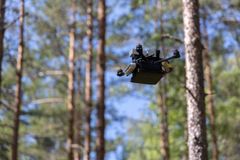
The relatively cold early summer has slowed down the spruce bark beetle’s activity, but there is no end in sight for the forest damage – drones are used to detect damage to trees faster than before
The spruce bark beetle belongs to Finnish nature, but the forest damage it causes has increased significantly since the 2010s. The beetle causes financial losses of millions of euros in commercial forests every year. Researchers at the National Land Survey of Finland have developed an artificial intelligence method that helps detect the early signs of damage faster.

The spruce bark beetle population has strengthened, and the areas of damage have spread further north, and this trend seems to be continuing. The spread has been particularly affected by the warming climate, the dry summer seasons and wind damage.
In its research projects, the National Land Survey’s Finnish Geospatial Research Institute (FGI) has developed a method based on photography carried out by drones and artificial intelligence analysis that can detect the impacts of spruce bark beetles and the deterioration of trees much better than the human eye.
Research Professor Eija Honkavaara finds that the method has potential for preventing spruce bark beetle damage.
“Our research has two main objectives. First, our aim is to monitor the progress of the spruce bark beetle damage. This allows us to see the direction in which the damage is advancing and to target the actions at the right areas. Second, we are developing methods to find the individual trees contaminated by the spruce bark beetle at an early stage. This would allow precise actions to be taken to control the damage.”
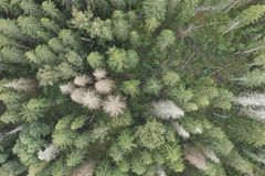
The artificial intelligence method looks for individual spruce trees in the photographs taken by drones and classifies them as healthy, deteriorated and dead.
“From the hyperspectral images collected with drones, it was already possible to detect the fresh impacts of spruce bark beetles within 3 to 5 weeks, while the tree tops were still green. The result is promising, as it provides time to react before a new generation can develop into adults and swarm towards new target trees. In addition, we are developing new mapping drones that fly inside the forest and can immediately find the impacts,” Honkavaara says.
Damage is also visible in the Helsinki region
The variation in the numbers of spruce bark beetles, the change in the health of trees and the progression of forest damage are also studied with pheromone traps for the beetles and by monitoring symptoms in trees in test areas. The data is used to train the artificial intelligence.
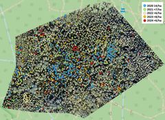
One of the test areas is in Paloheinä, in Helsinki. The research team has been monitoring the situation in the area since 2020.
“In the starting situation, there were 14 dead spruce trees per hectare in the research area. Between 2021 and 2024, there were 6 to 8 more of them per hectare per year. So, during the monitoring period, the spruce bark beetle killed about 40 spruce trees per hectare,” says Research Scientist Emma Turkulainen.
This year, the cold early summer has slowed down the reproduction of spruce bark beetles. For example, only one generation of beetles is expected in Paloheinä this summer. However, it is likely that forest damage caused by the beetles will continue to spread in the coming summers.
“Our research enables forest health monitoring that can be scaled to cover large areas and has low emissions. Drone-based technologies can also be combined with satellite remote sensing. With the aid of these methods, it will be possible to study the impact of the environment and conditions on the health of trees more extensively,” Eija Honkavaara says.
Contacts
Eija Honkavaara, Research Professor, National Land Survey of Finland, +358 029 531 4716, firstname.lastname@nls.fi
Images
Links
We perform cadastral surveys, maintain information about properties and dwellings, handle registrations of title and mortgages, produce map data and promote the research of spatial data.
Subscribe to releases from Maanmittauslaitos
Subscribe to all the latest releases from Maanmittauslaitos by registering your e-mail address below. You can unsubscribe at any time.
Latest releases from Maanmittauslaitos
Suomi rakentaa nyt datasta kilpailuedun – Maanmittauslaitos on paikkatiedon ytimessä2.12.2025 08:00:00 EET | Tiedote
Maanmittauslaitoksen tieteellisen huipputeknologian ja käytännön tuen avulla Suomi pystyy rakentamaan entistä älykkäämpää infrastruktuuria.
Pienet taloyhtiöt pääsevät nyt ilmoittamaan taloyhtiöidensä remontti- ja lainatiedot huoneistotietojärjestelmään1.12.2025 09:00:00 EET | Tiedote
Omatoimisesti isännöidyt taloyhtiöt voivat ilmoittaa taloyhtiöiden hallinnollisia tietoja huoneistotietojärjestelmään Maanmittauslaitoksen uudessa verkkopalvelussa 1.12.2025 alkaen. Taloyhtiön hallinnollisia tietoja ovat tiedot esimerkiksi taloyhtiön remonteista ja lainoista.
Kymmenille tuhansille taloyhtiöille pakollinen velvoite – vain pienimmät vapautettu1.12.2025 09:00:00 EET | Tiedote
Isännöintiala, pankit ja Maanmittauslaitos tekevät parhaillaan taloyhtiöiden tietojen ylläpidossa merkittävää digisiirtymää Maanmittauslaitoksen huoneistotietojärjestelmään. Isännöitsijöille tämä tarkoittaa uutta tehtävää: heidän täytyy ilmoittaa taloyhtiön remontti- ja lainatiedot järjestelmään ensimmäisen kerran kesäkuun loppuun 2026 mennessä.
Tutkijat onnistuivat jakamaan pyöräilijöiden liikkumisreiteistä hyödyllistä tietoa niin että tiedon jakajan yksityisyys huomioidaan4.11.2025 06:03:00 EET | Tiedote
Ruuhkaiset väylät, ahtaat reitit, vaaralliset paikat ja läheltä piti -tilanteet aiheuttavat kaupungeissa ongelmia liikkumisessa. Liikenne- ja ympäristösuunnittelussa olisi arvokasta pystyä käyttämään tarkkaa ja ajantasaista tietoa siitä, missä liikutaan ja milloin. Samanaikaisesti meistä jokaisesta älylaitteen käyttäjästä kerätään valtava määrä sijaintitietoa – joko aktiivisesti esim. liikuntasovelluksilla tai passiivisesti esim. navigointisovelluksilla. Maanmittauslaitoksen Paikkatietokeskus FGI:n tutkijat kehittivät ratkaisun, jonka avulla tällaista tarkkaa liikkumistietoa pystytään jakamaan avoimena datana – mutta ilman tunnistettavaa tietoa tiedon jakajasta.
Oletko nähnyt droonin lentämässä metsässä tai pellolla? Se voi olla Maanmittauslaitoksen tutkimusdrooni21.10.2025 06:03:00 EEST | Tiedote
Maanmittauslaitoksessa on käynnissä lukuisia drooneihin liittyviä tutkimushankkeita, joissa tuotetaan tietoa muun muassa metsätuholaisten ja metsäpalojen ehkäisemiseksi sekä maatalouden innovaatioihin. Drooneilla tehtävässä kaukokartoituksen tutkimuksessa Suomi edustaa alan kansainvälistä tieteellistä huippua.
In our pressroom you can read all our latest releases, find our press contacts, images, documents and other relevant information about us.
Visit our pressroom