The state of the Baltic Sea still far from the objectives – monitoring extending from coastal waters to the open sea explains why
18.9.2026 08:30:00 EEST | Suomen ympäristökeskus | Press release
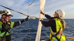
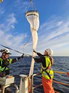
In August, the Finnish Environment Institute carried out two monitoring cruises in the Baltic Sea: Research vessel Aranda collected data from the open sea and M/S Hessu from the Archipelago Sea and the coast. Eutrophication remains the biggest environmental problem in the Baltic Sea. According to the status assessment of coastal waters, published in June, only six per cent of Finnish coastal waters are in a good state. Recent measurements and modelling provide an updated situational picture of how nutrient pollution from land is reflected in coastal waters and the open sea, and why the state of the sea is still far from the objectives.
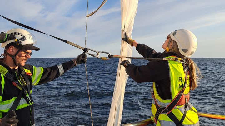
The measurements carried out in August complement the long-term monitoring of the Baltic Sea, which extends from coastal waters to the open sea. The measurements indicate the state of the sea and the direction of its development. Observations obtained during monitoring missions can be used to assess how the impacts of eutrophication are visible in different sea areas and how recent observations relate to long-term developments.
According to the preliminary results from research vessel Aranda, the nutrient concentrations in the open sea areas in the Gulf of Finland, the Bothnian Sea, the Bothnian Bay and the northern part of the main basin of the Baltic Sea are mainly at the level observed in previous years. Nutrient levels and the impacts of land-based nutrient loads vary between different sea areas. They are also affected by the flow of seawater between the basins of the Baltic Sea. In the deeper areas of the Gulf of Finland and the Baltic Sea main basin, the seabed is regularly anoxic, and oxygen depletion also occurs in the bottom water layers. This year, oxygen depletion in the bottom water layers occurred in a wider area than before.
Excessive nutrient loading increases algal production and may weaken oxygen conditions near the seabed. The marine ecosystem responds to changes in nutrient loading slowly, due to complex internal interactions and long nutrient turnover times. Nutrient levels also fluctuate naturally, depending on weather conditions, for example.
Long-term monitoring plays a key role in measuring and assessing the health of the marine ecosystem.
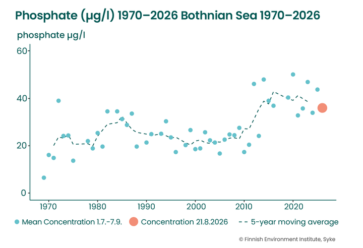
One of the key variables in long-term monitoring is the concentration of phosphate-phosphorus in the bottom water layer (Figure 1). Phosphate-phosphorus is a form of phosphorus that planktonic algae use directly for their growth. Phosphate-phosphorus concentration development help to identify changes in eutrophication and oxygen conditions that can have a long-term effect on the state of the sea.
In the Bothnian Sea, the concentration of phosphate-phosphorus in the bottom water increased in the 2010s, but this trend has stabilised in recent years.
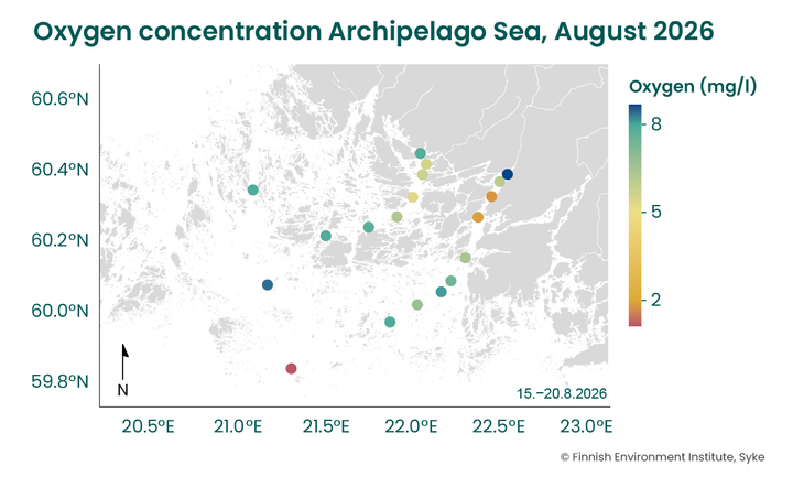
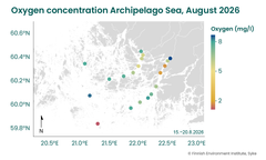
Open sea monitoring is complemented by coastal monitoring in the Archipelago Sea. It shows how the impacts of eutrophication vary in different parts of the archipelago. The measurements carried out in coastal waters indicated that the oxygen situation at observation sites in the outer archipelago is mainly better than in the inner and middle archipelagos (Figure 2).
“Nutrient loading from land, especially from agriculture, has a direct impact on algal growth and an indirect impact also on oxygen conditions in bottom water. The impact is strongest in the inner archipelago. In the outer and middle archipelago, nutrient and oxygen concentrations are also significantly affected by water exchange with the open Baltic Sea. The low oxygen concentration measured at the southwesternmost observation site is presumably due to the low-oxygen water mass flowing from the Baltic Sea main basin to the deeper water layers near the seabed,” says Group Manager Vivi Fleming from the Finnish Environment Institute.
Route from coastal waters to the open sea
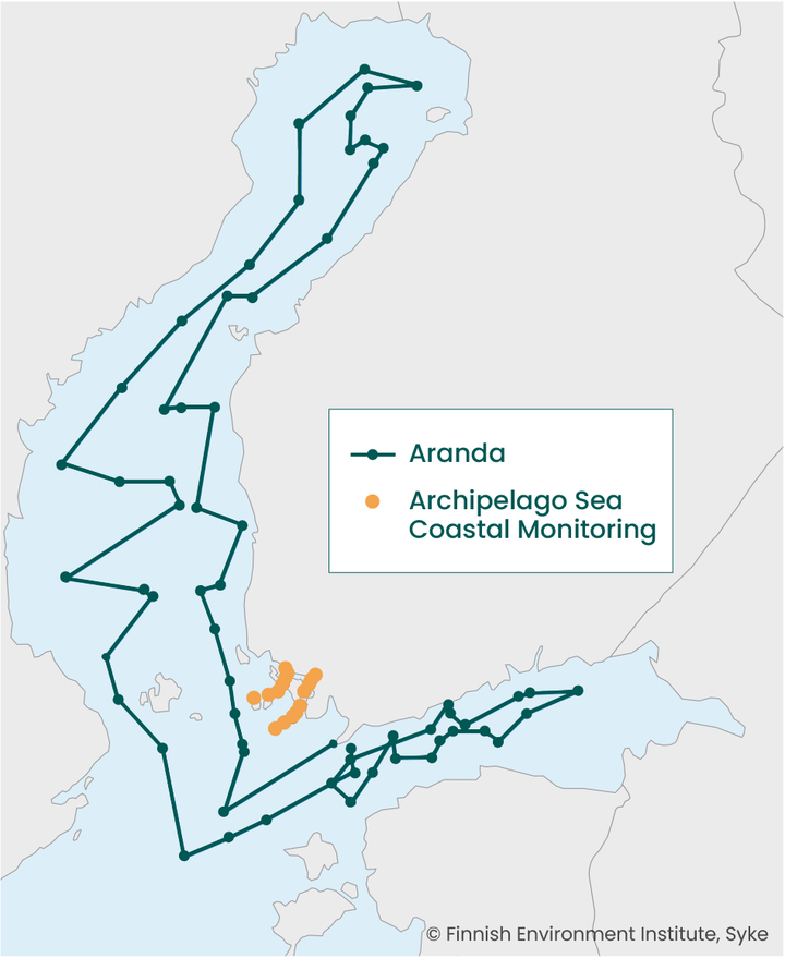
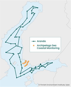
The monitoring cruises in August examined the Baltic Sea from coastal waters to the open sea (Figure 3). The research vessel Aranda travelled from the Gulf of Finland to the northern parts of the main basin of the Baltic Sea, the Archipelago Sea and further to the Bothnian Sea and the Bothnian Bay. At the same time, coastal monitoring examined water quality in the sampling lines of Paimionlahti and Airisto from the coastal areas to the outer Archipelago Sea.
Aranda’s cruise is part of the joint HELCOM COMBINE monitoring programme of the Baltic Sea countries, which monitors the physical, chemical and biological status of the sea. The coastal monitoring of the Archipelago Sea measured, among other things, nutrient concentrations, oxygen levels, amounts of algae and other variables related to eutrophication and climate change.
Combining observations and modelling provides a comprehensive overview
The measurements show what is happening in the sea at the moment. The modelling, on the other hand, can be used to assess the reasons for the observed changes and how different water protection measures would affect them.
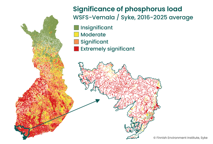
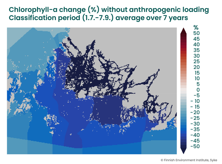
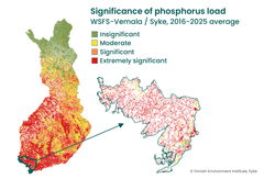
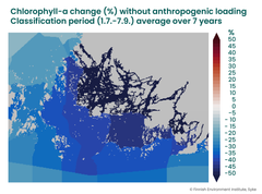
The Finnish Environment Institute’s WSFS-Vemala model describes the nutrient loading caused by human activities in different catchment areas (Figure 4). The Finnish coastal nutrient load model FICOS, in turn, shows how the nutrient loading estimated by the catchment area model is reflected in the water quality and algal biomass in sea areas (Figure 5). Together, they enable the comparison of different measures and scenarios. For example, Figure 5 illustrates a hypothetical situation in which nutrient loading from local human activities in the Archipelago Sea catchment has been eliminated.
Objectives remain unachieved – but the direction can be influenced
According to the surface water status assessment published in June, good coastal water status with regard to eutrophication will not be achieved by 2027. Although the objectives are not met on schedule, decades of monitoring and complementary modelling help to identify the causes of eutrophication and assess the impacts of water protection measures. In this way, measures can be targeted where they achieve the greatest benefit.
Nutrients flow into the Baltic Sea from its entire catchment area, which extends to 14 countries, all the way to Belarus and Ukraine. As nutrients are carried by rivers and sea currents across municipal, regional and national borders, solutions also require cooperation from catchments to coastal waters and across the entire Baltic Sea level.
Keywords
Contacts
Group Manager Hermanni Kaartokallio, tel. +358 29 525 1247, e-mail: forename.surname@syke.fi
Communications Specialist Eija Järvinen, tel. +358 29 525 1242, e-mail: forename.surname@syke.fi
Media service at Finnish Environment Institute
Our Media Service provides information on research, helps journalists find experts for interviews and provides photos for media use.
Our Communication experts will answer your inquiries on weekdays from 9 am to 4 pm.
Images
Finnish Environment Institute - We build hope through research.
Finnish Environment Institute
Latokartanonkaari 11
00790 Helsinki
+358 295 251 000
It is time to move beyond solving environmental problems one by one, to systemic sustainability transformations. The Finnish Environment Institute (Syke) contributes to building a sustainable society through research, information and services. The Finnish Environment Institute is a research institute with 700 experts and researchers located in Helsinki, Oulu, Jyväskylä and Joensuu.

Subscribe to releases from Suomen ympäristökeskus
Subscribe to all the latest releases from Suomen ympäristökeskus by registering your e-mail address below. You can unsubscribe at any time.
Latest releases from Suomen ympäristökeskus
Östersjöns tillstånd är fortfarande långt från målen – uppföljning som sträcker sig från kustvatten till öppet hav visar varför18.9.2026 08:30:00 EEST | Pressmeddelande
I augusti genomförde Finlands miljöcentral två uppföljningsresor i Östersjön: havsforskningsfartyget Aranda samlade in information från öppet hav och ms Hessu från Skärgårdshavet och kusten. Övergödning är fortfarande Östersjöns största miljöproblem. Enligt den statusbedömning av kustvattnen som publicerades i juni har endast sex procent av Finlands kustvatten god status. Färska mätningar och modelleringar ger en uppdaterad lägesbild av hur näringsbelastningen från land syns i kustvattnen och på öppet hav och varför havets tillstånd fortfarande är långt från målen.
Itämeren tila on yhä kaukana tavoitteista – rannikkovesistä avomerelle ulottuva seuranta kertoo miksi18.9.2026 08:30:00 EEST | Tiedote
Suomen ympäristökeskus toteutti elokuussa Itämerellä kaksi seurantamatkaa: merentutkimusalus Aranda keräsi tietoa avomereltä ja ms Hessu Saaristomereltä ja rannikolta. Rehevöityminen on edelleen Itämeren suurin ympäristöongelma. Kesäkuussa julkaistun rannikkovesien tila-arvion mukaan vain kuusi prosenttia Suomen rannikkovesistä on hyvässä tilassa. Tuoreet mittaukset ja mallinnukset tarjoavat päivitetyn tilannekuvan siitä, miten maalta tuleva ravinnekuormitus näkyy rannikkovesissä ja avomerellä, ja miksi meren tila on edelleen kaukana tavoitteista.
Nostot medialle 21.–25.9.2026: Miksi Itämeren tila on yhä kaukana tavoitteista? Metsien ennallistamisessa etsitään tasapainoa metsäluonnon tilan parantamisen ja metsätalouden välillä17.9.2026 13:46:33 EEST | Tiedote
Hei! Tässä tiedoksesi meillä Suomen ympäristökeskuksessa ensi viikolla ilmestyviä tiedotteita, uutisia, kampanjoita, blogeja ja uutiskirjeitä. Mukana myös tulevia tapahtumia ja webinaareja. Jakelemme mediakatsauksen torstaisin STT:n kautta. Koosteet löytyvät myös STT-uutishuoneesta, josta voit tilata kaikki Suomen ympäristökeskuksen tiedotteet.
Metsien ennallistamisessa etsitään tasapainoa metsäluonnon tilan parantamisen ja metsätalouden välillä16.9.2026 14:55:34 EEST | Tiedote
Metsäluonnon ekologista tilaa on mahdollista parantaa yhteistyössä metsätalouden kanssa, painottavat Suomen ympäristökeskuksen (Syke) tutkijat. Arvokkaimpia kohteita voidaan suojella, kun taas muualla luonnon tilaa voidaan parantaa metsätalouden rinnalla ennallistamisasetuksen avulla.
Finland's cormorant population decreased by seven per cent14.9.2026 08:22:00 EEST | Press release
Both the number of nests and the number of occupied colonies were clearly below the levels of the previous two years.
In our pressroom you can read all our latest releases, find our press contacts, images, documents and other relevant information about us.
Visit our pressroom