
Satellites capture socioeconomic disruptions during the 2022 full-scale war in Ukraine
Satellite observations show significantly reduced air pollution levels over the major Ukrainian cities, power plants and industrial areas.
Since February 2022, the full-scale war in Ukraine has been strongly affecting society and economy in Ukraine. Satellite observations provide crucial information to objectively monitor and assess the impacts of the war.
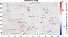
A new paper published today on Scientific Reports utilizes satellite observations of air pollutants and other relevant parameters from multiple platforms to assess the impacts of the ongoing war on the Ukrainian society. Satellite observations show that the concentrations of nitrogen dioxide (NO2), which is emitted through fossil fuel combustion processes, declined in 2022 over the major Ukrainian cities, power plants and industrial areas by 15–46%.
Such reductions reflect the decrease in population and corresponding emissions from the transport and commercial or residential sectors as well as the decline in industrial production, especially from the metallurgic and chemical industry, which led to a reduction in power demand and corresponding electricity production from power plants. Carbon dioxide (CO2) observations also indicate reductions in fossil fuel combustion, especially in eastern Ukraine, where the largest emission sources are located.
“During peaceful times, reductions in nitrogen dioxide concentrations as those observed here would be considered as a welcome improvement of air quality and human health. In this case, the observed changes tell a different story about the extent of the disruption caused by the war on the Ukrainian society and economy. Also, the reductions in fossil fuel consumption in Ukraine might have been partly offset by an increase elsewhere”, explains senior researcher at the Finnish Meteorological Institute Iolanda Ialongo, who led the work.
Exceptional fire patterns near the front line
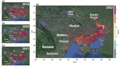
Satellite imagery and fire detections indicate an anomalous distribution of fires along the front line, which are attributable to shelling or other war-related fires, rather than the typical homogeneously distributed fires related to crop harvesting. Satellite imagery data also show drastic changes over the city of Mariupol, which was attacked during the first three months of the war.
The signal from the hot smokes from the metallurgic industrial facilities in the city disappears from the satellite imagery after March 2022, which suggest an interruption of industrial activities, and, correspondingly, NO2 levels decreased.
The results are based on the NO2 retrievals from the European TROPOMI (TROPOspheric Monitoring Instrument), onboard the Sentinel 5 Precursor satellite, and the CO2 observations from the NASA’s OCO-2 satellite. Also satellite imagery from the Sentinel 2 satellite was analyzed as well as fire detections from the Visible Infrared Imaging Radiometer Suite (VIIRS).
The research was carried on at the Finnish Meteorological Institute together with colleagues from the University of Lviv (Ukraine) and USRA (USA). The Finnish part of the research was supported by the Ministry for Foreign Affairs of Finland via the Interinstitutional Development Cooperation Instrument (ICI), UHMC-FMI Meteorology project and the Research Council of Finland.
Keywords
Contacts
Senior researcher Iolanda Ialongo, Finnish Meteorological Institute, iolanda.ialongo@fmi.fi
Images
Links
Alternative languages
Subscribe to releases from Ilmatieteen laitos
Subscribe to all the latest releases from Ilmatieteen laitos by registering your e-mail address below. You can unsubscribe at any time.
Latest releases from Ilmatieteen laitos
Merijään ilmastoa jäähdyttävä vaikutus pienenee sen pinta-alaa nopeammin17.7.2024 16:11:44 EEST | Tiedote
Kiihtyvä napa-alueiden merijääpeitteen sulaminen vähentää sen jäljellä olevaa jäähdytystehoa, mikä osaltaan edistää ilmaston lämpenemistä.
Ilmansaasteita mittaava suomalais-hollantilainen OMI-satelliittimittalaite toiminut avaruudessa jo ennätykselliset 20 vuotta12.7.2024 10:05:09 EEST | Tiedote
Maanantaina 15.7.2024 tulee kuluneeksi tasan 20 vuotta siitä, kun suomalais-hollantilanen Ozone Monitoring Instrument (OMI) laukaistiin avaruuteen Nasan EOS-Aura satelliitin kyydissä kolmen muun ilmakehää havainnoivan mittalaitteen kanssa.
Viimeiset 12 kuukautta olleet globaalisti 1,5 astetta lämpimämpiä esiteolliseen aikaan verrattuna8.7.2024 05:00:00 EEST | Tiedote
Maapallon keskilämpötila ollut viimeisen vuoden ajan ennätyksellisen korkea.
Kesäkuu alkoi ja päättyi helteisiin, sateita tuli vaihtelevasti1.7.2024 11:57:36 EEST | Tiedote
Kesäkuun alku- ja loppupuolella oli helleputki, suurimmassa osassa maata oli tavanomaista lämpimämpää. Kuukauden sademäärät vaihtelivat paljon alueittain. Kesäkuun salamakeskiarvo ylitettiin jo kuukauden kahtena ensimmäisenä päivänä.
Maanantaina runsaita sateita ja mahdollisesti vaarallista ukkosta30.6.2024 13:54:31 EEST | Tiedote
Lauantaiseen Pekka-rajuilmaan liittyi voimakkaita ukkospuuskia. Maanantaiksi Suomeen saapuva matalapaine tuo uusia sateita ja ukkosia.
In our pressroom you can read all our latest releases, find our press contacts, images, documents and other relevant information about us.
Visit our pressroom